New sensor: Web Map Tile Service
We have added the sensor Web Map Tile Service to Digi3D.NET! This sensor will allow you to connect to Map Tiles Web Services such as PNOA High Resolution Orthophotos. The Web Map Tile Service servers differ from the Web Map Service in that they are not so configurable, and the responses that the server returns are static maps, it is not possible to add dynamically layers and information but they have the advantage of being much faster because being static maps these can be cached on the server which means that they respond much faster than the Web Map Service servers. In addition, these load much less servers that can be stupid unlike the Web Map Service, which always require some intelligence on the server side. The sensor Web Map Service will end up disappearing from Digi3D.NET in the photogrammetric window, and will remain in the drawing window, which is where it always had to be, because in the drawing window we can interact with its controls and dynamically add/delete layers and representations. To use this sensor, we only have to follow the following steps:
- Select the sensor type in the Photogrammetric Sensors tab of the New project dialog box.
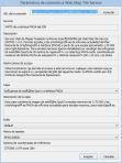 Press the three dots button that appears when clicking on the Connection String field. The Web Map Tile Service Connection Parameters dialog box will appear.
- Fill in the server URL Web Map Tile Service in the URL of the connection field.
(you can see a list of WMTS servers on the following page: IDEE Geoportal Maps Tessellation Web Services - Select the layer that interests us in the drop-down Layer.
- Select the style in the drop-down Style.
- Select the map to be displayed by selecting it in the drop-down Tile matrix set.
Each map has an associated reference coordinate system that we can see in the Reference Coordinate System field.

Below is a video showing this functionality: [youtube=http://youtu.be/Gw04PA5jtZ8]