What's new in the coordinate reference system selection dialog box
There are different coordinate reference systems:
- Horizontal 2D (for coordinates X,Y or Latitude,Longitude)
- Horizontal 3D (which are always geographic coordinates Latitude,Longitude,H (being H ellipsoidal altitude)
- Vertical (for coordinates Z)
- Geocentric (for orthogonal coordinates with the origin of the system in the center of the earth)
- Composites (constituted by a horizontal system 2D and a vertical system)
Until now, whenever Digi3D.NET needed to know about the reference coordinate system of a certain object such as the drawing window, or a photogrammetric model, it asked the user on the one hand the horizontal reference coordinate system and on the other hand the vertical coordinate system. This made it impossible to work in horizontal systems 3D, so that if we wanted to restore a satellite model with coordinates * (Latitude, Longitude, H ellipsoidal) *, we had to select as reference coordinate system * WGS 84 * for example and as vertical select * unknown * since there is no reference coordinate system * ellipsoidal *. We have modified the program in several aspects:
Now all the coordinate systems that we select will be 3D, so that where before it was asked for the horizontal and vertical, now it is asked for a single reference coordinate system.
The windows that display the title of the reference coordinate system show in a single line the name of the system, if it is composed the name is displayed as follows: horizontal + vertical as for example WGS 84 / UTM Zone 30N + EGM08 REDNAP.
We have completely redesigned the reference coordinate system selection dialog box.
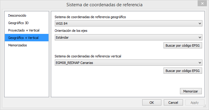 The new dialog box has the following new features:
Only allows to form systems 3D, which can be either a horizontal system 3D or a composite system formed by a geographic for the horizontal + one vertical or one projected for the horizontal + one vertical
Allows you to indicate the direction of the axes in geographic systems (both 2D and 3D).
We can select one of the following options:
- Standard, which means that the reference coordinate system to be created has the axes as defined by its creator.
- Latitude and Longitude.
- Longitude, Latitude. This is important because sometimes thanks to these options we can specify the order of the coordinates when exporting to a Shapefile for example.Other programs do not comply well with the OpenGis standard and expect to receive Longitude,Latitude even though the coordinate reference system associated with the shapefiles clearly indicates that the coordinates must be Latitude, Longitude.