Generating orthophotos with Digi3D.NET
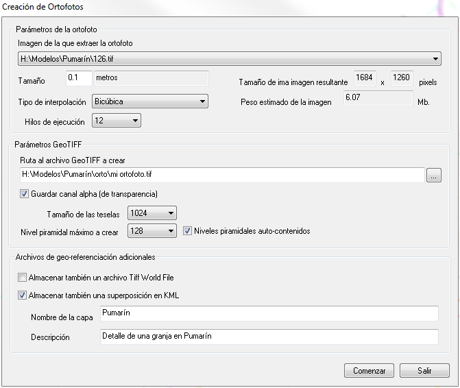 Digi3D.NET allows to calculate orthophotos using the command CAL_ORTHO.
This command has evolved from previous versions of Digi3D, incorporating the following new features:
- Multi-processing. The calculation of the orthophoto is done in parallel, so the more cores we have, the faster the orthophoto will be calculated. In the screenshot that heads this entry, you can see that the orthophoto calculation dialog box allows you to indicate the number of execution threads with which the calculation will be done. The dropdown varies depending on the number of processors that the computer where the command is being executed has. In the screenshot you can see that 12 execution threads have been selected. This means that if we compare it with previous versions of Digi3D or OrthoBatch, the calculation of the orthophoto will be generated 12 times faster on the same machine.
- GeoTIFF. The orthophoto will be created in the same coordinate system as the drawing window. Since Digi3D.NET knows at all times the coordinate system of the drawing window, it will store that information in the header of the GeoTIFF along with the geo-reference of the orthophoto. In this way, any program that allows to load orthophotos (such as Digi3D.NET, GlobalMapper) does not even need to generate an associated .Tfw file.
- Alpha channel. We can indicate if we want to generate a transparency channel that is a standard mechanism for pixels that are outside the orfototo (outside the digital terrain model or the original image) instead of the system that use Digi3D 2007 and OrthoBatch to indicate that a certain color should be considered as transparent. Thus programs such as Photoshop will treat transparent pixels as transparent.
- Size of the tiles. The resulting image will be tiled (with tiles), in this way the programs that load our orthophoto will be able to optimize memory. The dialog box of calculation of orthophotos will allow us to indicate the size of the tiles.
- Pyramid levels We can also indicate if we want to generate pyramid levels, the maximum pyramid level and whether or not we want them to be self-contained within the image itself.
- Additional georeferencing. You can also choose whether to generate additional georeferencing files. GeoTIFF files are already georeferenced, but you may want to generate TIFF World Files for applications such as older versions of Digi3D that cannot read GeoTIFF. You can also generate a Google Earth overlay layer: double-clicking the layer file opens Google Earth and displays your brand-new orthophoto.
Below is a video in which you can see all this in action.